
README file from
GithubAdvanced Maps


English · 简体中文 · User guide
Turn Obsidian's native Maps view into a photo atlas, a route viewer, and a map of the notes connected to the one you are reading.
Advanced Maps reads GPS from whole photo folders, draws GPX/GeoJSON/KML/TCX routes and areas, and creates an Around view from ordinary Obsidian links. It extends the first-party Maps view instead of replacing it: MapLibre, backgrounds, markers, popups, and every built-in map option remain native. No Leaflet, no bundled renderer, no runtime dependencies.
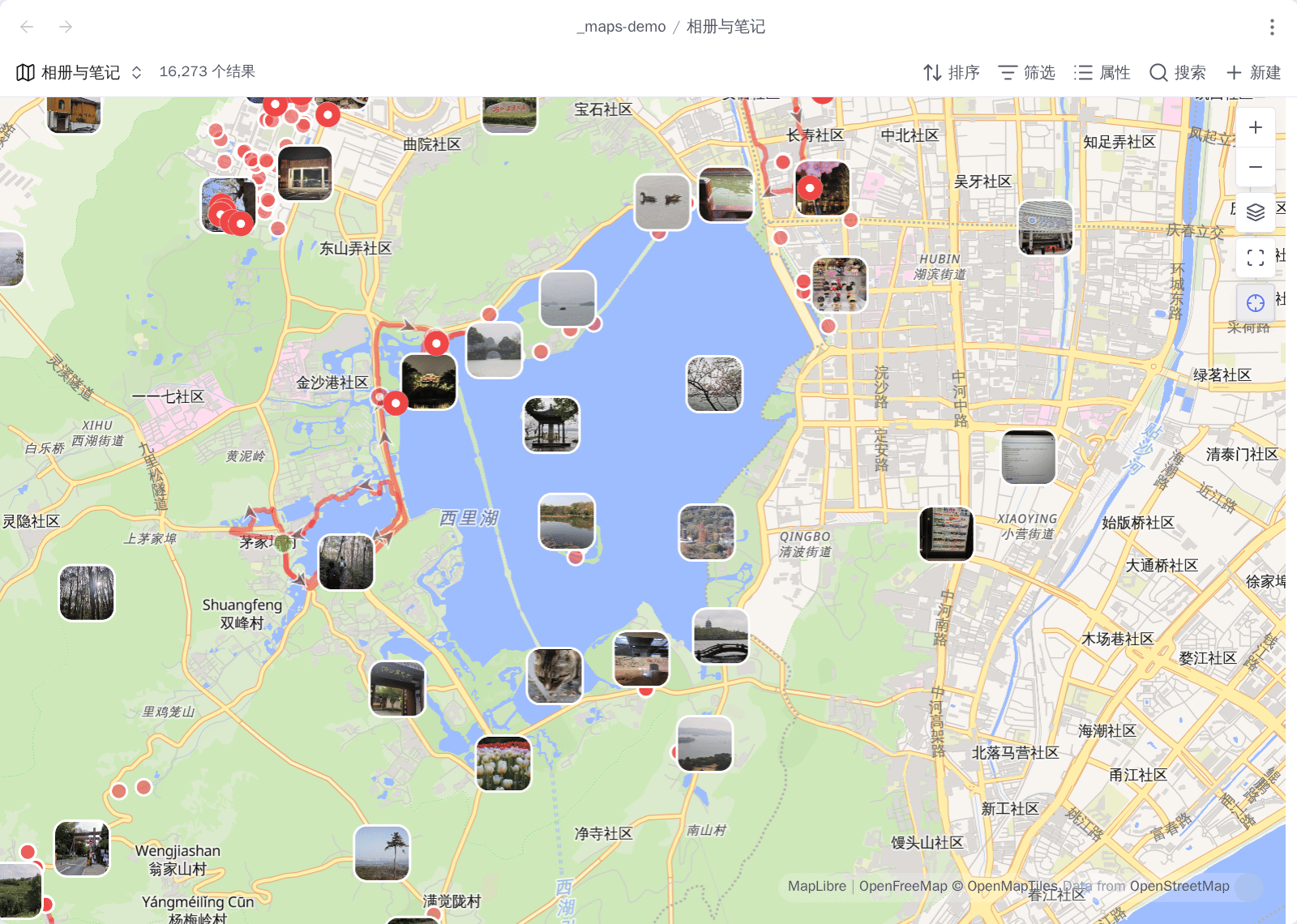
One Base, one map: red pins are place notes, thumbnails are photos placed by
their own EXIF, and the line is a .gpx a note links to. 16,273 results.
Three workflows
| Use Advanced Maps as… | Put this in the Base | What appears |
|---|---|---|
| A map photo album | A photo folder, including a link to an external album | Every photo with readable GPS, at its EXIF location |
| A route viewer | Notes linked to .gpx, .geojson, .kml, or .tcx files—or those files alone |
Routes, areas, markers, photos, elevation, and statistics a Base can sort on |
| An Around map | Your place-note collection | The current note, its links and backlinks, plus their tracks and photos |
These compose. One map can show place notes, a multi-day route, and every geotagged photo taken along it.
Requirements and install
Advanced Maps requires Obsidian 1.13.1 or newer with Bases enabled and the first-party Maps plugin installed. Without that native view, it reports or skips the unavailable enhancement and leaves Obsidian usable.
- Release: copy
main.js,manifest.json, andstyles.cssfrom Releases into<vault>/.obsidian/plugins/advanced-maps/, then enable the plugin. - BRAT: add
Jin1c-3/obsidian-advanced-maps.
Quick start
Save this as atlas.base, replace the folder paths, open it, and choose its map
view:
filters:
  or:
    - file.inFolder("places")
    - file.inFolder("assets/onedrive/Pictures")
views:
  - type: map
    name: Atlas
    coordinates: coords
    trackWeight: 4
    trackOpacity: 85
    fitMaxZoom: 16
The first branch maps notes whose coords property holds a coordinate. The
second maps supported photos directly from their GPS metadata. See
Getting started for the Base boundary, view
keys, supported photos, and the next recipes.
User guide
| Topic | Covers |
|---|---|
| Getting started | Installation, Base boundaries, first map, view keys |
| Photo maps | Photo folders, OneDrive, linked photos, thumbnails, index |
| Tracks and areas | Route links, inline maps, GPX/GeoJSON/KML/TCX, polygons, statistics as properties |
| Around and navigation | Around views, reusable Base, Open in map, follow, shared pins |
| Places in and out | Importing a file of placemarks as notes, exporting a Base as GPX/KML/CSV |
| Offline basemap | Tiles already on disk as the background, zoom bounds, per-view opt-out |
| Coordinates and services | WGS-84/GCJ-02/BD-09, external maps, search, geocoding, location |
| Reference and privacy | Supported inputs, option ownership, operational limits, network disclosure |
Notes, tracks, and photo contents do not leave on their own. The plugin has no telemetry, update ping, or server; the privacy reference lists the requests made when you use maps or external services.
Project documentation
- CONTRIBUTING.md: setup, testing, pull requests, and releases.
- OpenSpec capabilities: stable technical contracts.
- CHANGELOG.md: released behavior.
- ROADMAP.md: possible future work and deliberate non-goals.
Licence
MIT.